The Search for Malaysia Airlines Flight 370
The search for Malaysia Airlines Flight 370
About an hour after taking off from Kuala Lumpur, Malaysia on Saturday, March 8, a Boeing 777-200ER jetliner with 239 people on board went missing while flying to Beijing. Below is a brief summary of what we know about the search for flight 370. Full coverage »
Malaysian PM: Flight ended in Indian Ocean
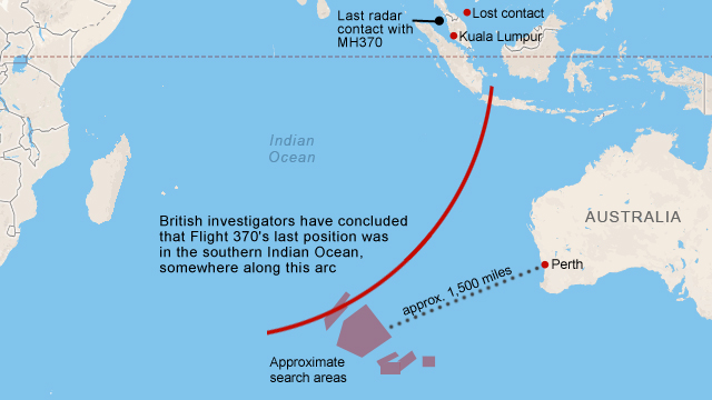
Malaysia Airlines Flight 370 went down over the southern Indian Ocean, Malaysian Prime Minister Najib Razak said Monday, citing a new analysis of satellite data by British satellite company and accident investigators.
The Prime Minister based his announcement on what he described as unprecedented analysis of satellite data sent by the plane by British satellite provider Inmarsat and the British Air Accidents Investigation Branch. He said the analysis made it clear that the plane's last position was in the middle of the remote southern Indian Ocean, "far from any possible landing sites."

Possible debris found west of Australia
Although the search area spans a vast area of nearly 3 million square miles, a U.S. government official familiar with the investigation said the plane is most likely somewhere on the southern end of the search area."This is an area out of normal shipping lanes, out of any commercial flight patterns, with few fishing boats, and there are no islands," the official said, warning that the search could well last "weeks and not days."
Australian authorities announced Thursday the discovery of two objects captured on satellite and described as possible debris from Flight 370. Hindered by poor weather, and the remote nature of the location in the southern Indian Ocean, search crews were unable to spot the debris, which was photographed Sunday by a commercial satellite.
Australia's search area is based on analysis by the U.S. National Transportation Safety Board on "the fuel reserves of the aircraft and how far it could have flown," according to John Young of the Australian Maritime Safety Authority.

How far could it have gone?
Flight 370 was fueled for a trip to Beijing. Based on fuel estimates, the aircraft could have flown an additional 2,500 miles after the point of last contact.Malaysian authorities said March 13 they believe several "pings" of data from the airliner's service data system, known as ACARS, transmitted to satellites in the four to five hours after the last transponder signal, a senior U.S. official told CNN.
This information, combined with known radar data and knowledge of fuel range leads officials to believe the plane may have made it to the Indian Ocean.

Lost contact, apparent course change
Around 1:30 a.m. on March 8, air traffic controllers in Subang, outside Kuala Lumpur, lost contact with the Boeing 777-200ER over the sea between Malaysia and Vietnam. The plane's transponder, which identifies the aircraft and relays details like altitude and speed to controllers, stopped transmitting.A senior Malaysian air force official on Tuesday, March 11 said the flight was hundreds of miles off course and traveling in the opposite direction from its original destination. It was last tracked over over Pulau Perak, a tiny island in the Strait of Malacca at about 2:40 a.m., over an hour after air traffic controllers in Subang lost contact with the aircraft.
At a news briefing the next day, however, Gen. Rodzali Daud, head of the Malaysian Air Force, and other officials said it isn't yet clear whether the object that showed up on military radar flying over the sea northwest of the Malaysian coast early Saturday was the missing plane.
Thailand's military was receiving normal flight path and communication data from the Flight 370 until 1:22 a.m., when it disappeared from its radar, the Thai government announced on Tuesday, March 18. Six minutes later, the Thai military detected an unknown signal, a Royal Thai Air Force spokesman told CNN. This unknown aircraft, possibly Flight 370, was heading the opposite direction. This bolsters the belief that missing Flight 370 took a sharp westward turn after communication was lost.

The initial search areas
Several planes, ships and search crews from 14 countries initially began scouring the South China Sea near where the plane was last detected. After debris in the area and an oil slick turn out to be unrelated to the plane, the search area is expanded to include the waters west of Malaysia. China's State Administration for Science, Technology and Industry for National Defense release satellite photos of possible wreckage, but later announce that the release was a mistake, and the debris in the photos was unrelated to Flight 370.

The expanded search area
The map to the left, based on a handout from the Malaysia Prime Minister's office, highlights the current focused search area.
While official contact was lost with Flight 370 about 45 minutes after takeoff, officials believe a combination of military radar data and a satellite-based system called ACARS provide hints regarding the path of the plane.
Though no actual data was transmitted via satellite, it still appears to have made contact through hourly 'handshakes,' the last instance being at 8:11 a.m. local time somewhere along the red lines.
Sources: Malaysia Civil Aviation Authority, Malaysia Prime Minister's office, CNN, flightradar24.com, Australian Maritime Safety Authority, Google Maps


Comments